
Note: This year I am blogging weekly reflections at my school site (weskids.com) in order to provide more transparency in my teaching for parents, students, and the community (local and global). I will be cross-posting most of the entries here at Bit By Bit as well. You can see the original posts at the “Reflections by Mr. S” blog.
______________________________________________
Multi 1/2 and Grade 1 students have started exploring Google Earth — first as a whole group with me, and then in smaller groups in Centers. Google Earth is truly an amazing tool and never ceases to “wow” students.
Students first explored the application in what is known as “Sandbox Mode.” In Sandbox Mode, students get to explore and play with the tool before they get any instruction from a teacher. There are many reasons to do this, but primarily, it helps build students’ confidence in starting to figure out the application by themselves, and also gets them immediately in the “driver’s seat,” rather than painfully waiting through a direct instruction lesson before they can finally get their hands on the tool! Students explore the tool in a “low-risk” setting (have fun!) and take on the role of “instructor” as they share their discoveries with peers in partnerships, and then later when we come back together as a group.
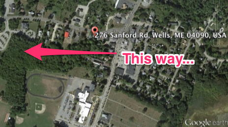
When we come back as a whole group, I start by showing how to search for our school in Google Earth by entering its address. One thing students see right away is that usually Google Earth can’t find the exact location to our school… It puts us down the road a bit:
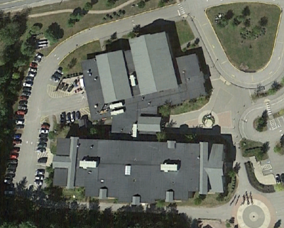
I next show how by clicking and dragging on the map, students can “walk” along the road to find our school:
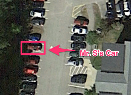
Students realize how relevant the pictures in Google Earth are when I show them my own car in the parking lot behind the school:
Once they see that, students start asking if I can find their own house in Google Earth! (I assure them that they will have time when they get back to Google Earth and that I will help them type the names of their streets).
I show a few more things on Google Earth, and then ask the students to figure out where the pictures of Earth come from and “Why are there no clouds?” This opens up a whole new discussion about technology!
When students go into small groups, they will search for landmarks around Wells.
Things you and your student can do at home:
- Download Google Earth! It’s FREE! It’s AMAZING!
- Work with some of the “Layers” that are included in Google Earth. Check out New York City with the 3D Buildings on!
- Find directions to relatives or friends and “fly” from your house to them to show how far it is.


Bob,
I like the idea of using Google Earth to show students actual satellite images of places on Earth. Starting with the school sounds like a great way to show that the program shows actual images. You wrote about students searching for landmarks. What would you have students do with the images or information found related to the images? I teach my students about landmarks in the different United States regions and would love to try adding this to our lesson. Thanks for sharing!